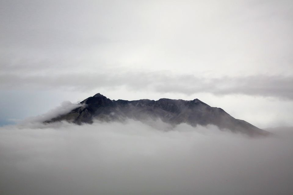


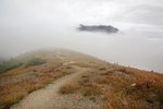
Stepping up to Johnston Ridge, I stared out into a wall of gray. I could barely make out the lip of Mount St. Helens, just as it disappeared – swallowed completely by the fog.
Hiking along the ridge on the north side of Mount St. Helens is typically an experience of continuous awe. With so many incredible views of the volcano and the landscape that was devastated by its famous 1980 eruption, the visit can be an extraordinarily humbling excursion.
But when mist or heavy fog settles over the pumice plains, obscuring those awesome views, there’s an opportunity for an even more moving experience.
That was the case during a recent late-summer hike from the Johnston Ridge Observatory to Harry’s Ridge, a popular destination for day hikers. Leaving the observatory behind, I hiked along Johnston Ridge following the dusty trail past steep gray cliffs dotted with late-season wildflowers. The morning fog refused to lift, obscuring everything beyond about a hundred yards in any direction.
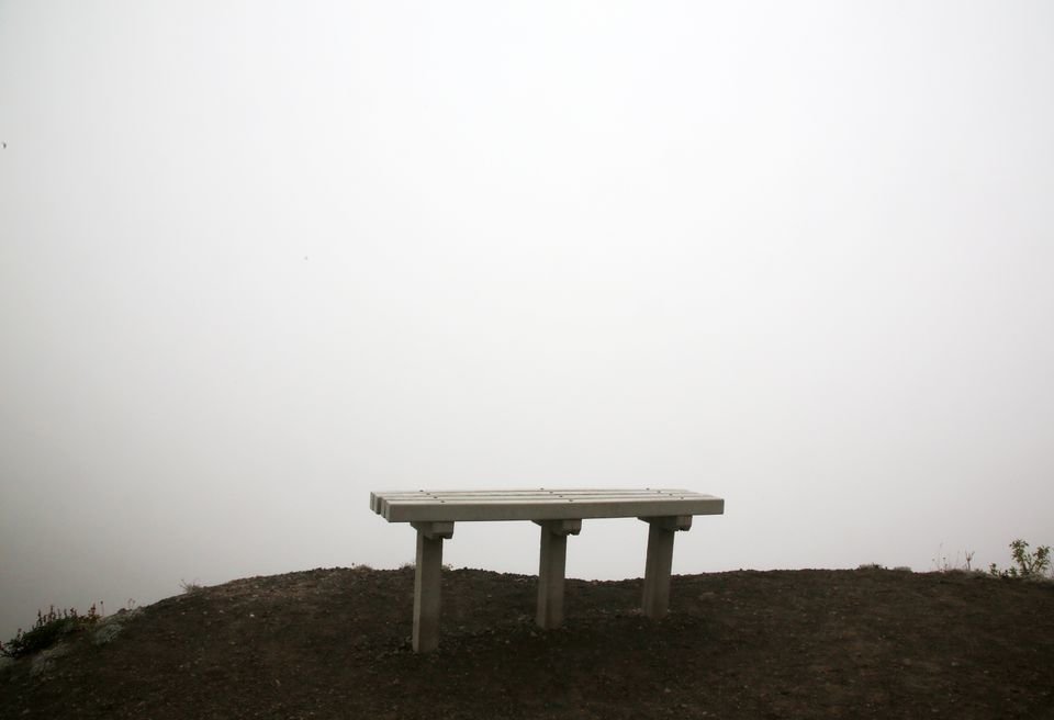
The hike soon became something of a spiritual experience: the volcano a powerful force that was hidden from view, its presence felt but never seen. I knew the volcano was out there, yet my eyes couldn’t confirm it. As I walked along the ridgeline, past viewpoints and empty benches, I had to take it on faith that Mount St. Helens was out there at all.
The hike to Harry’s Ridge is a good adventure, and one of the best hikes on the north side of the mountain. It’s just challenging enough for an intermediate hiker, but not too difficult for beginners. From the Johnston Ridge Observatory parking lot, the Boundary Trail runs about three miles to its intersection with the Harry’s Ridge Trail, which dead ends after about three-quarters of a mile. An out-and-back hike is about 8 miles, with a modest 1,564 feet in elevation gain.
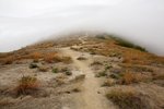
Much of the hike is spent on a snaking trail that crosses through an ashen landscape, the contours of the land shaped by the devastating avalanche of pumice, ash and steaming gases that exploded from the north side of the volcano in 1980. What once was a lush forest is now a moonscape in recovery, where tiny conifers and scrubby brush have since emerged from the debris.
Traversing that open landscape in the mist was like wandering through a dream. Without the volcano views, my attention was left to wander freely, discovering all the little things on the trail: red and purple wildflowers that stood out against the gray; hanging spiderwebs in the brush that were bejeweled by droplets of mist; songbirds perched in scrubby trees, their branches full of mist.
The persistent moisture chilled me to the bone, a mild annoyance that intensified as I began to hike up Harry’s Ridge. The short climb represents the most difficult portion of the hike, as the trail heads steeply up an open hillside. Wind blew the mist up and over the ridge, soaking one half of my body as I climbed. Surrounding the trail was a field of brown grass littered with old gray stumps that had been shattered by the volcanic blast – a graveyard of the former forest.
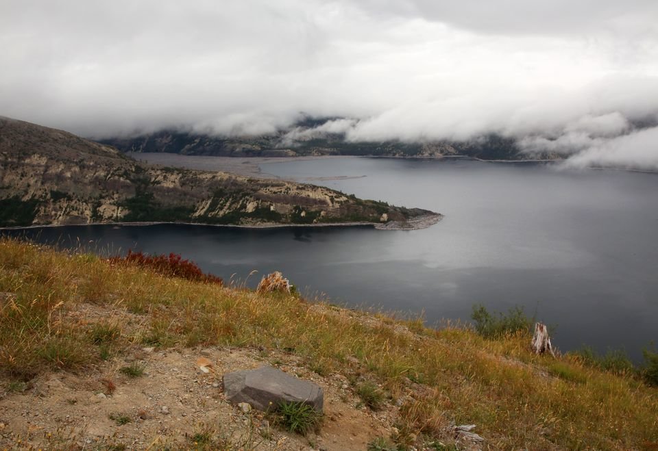
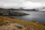
I crested the ridge and stared into the fog, which still lay heavy for miles in every direction, then followed the trail down the ridge a short way until it petered out at a viewpoint. From there, hikers can get a great view of Spirit Lake and Mount Adams to the left, with an amazing view of Mount St. Helens straight ahead and the desolate pumice plans to the right – none of which was visible through the fog.
I turned my back to the wind and sat down on an old, gray root to rest. As I took a drink of water, I stared out into the pall of gray when I noticed a faint rippling of water in the distance. Suddenly, I could make out a curving shoreline and the blue hue of Spirit Lake. I spun around to my right just in time to see the crooked silhouette of Mount St. Helens as it slowly emerged from the fog.
After a morning spent treating the volcano like some unseen deity, its sudden unveiling was revelatory. I felt fortunate to be standing in the one place where the fog parted just enough to give me a glimpse of the view that had otherwise remained hidden all day.
The volcano view seemed to remain open to me for as long as I decided to stand there, but eventually it was time to go. After hiking back up to the crest of the ridge, like Orpheus I cautiously turned back, hoping to get one last glimpse of Mount St. Helens. I looked just in time to see the lip of the volcano as it disappeared into the fog once again.
HARRY’S RIDGE HIKE
Distance: 8 miles round trip
Difficulty: moderate
Amenities: Parking lot, visitor center (currently closed)
This hike is rated “moderate” for some steep hills and the overall distance.
Begin the hike at the Johnston Ridge Observatory parking lot, which is found at the end of Washington State Route 504. The end of this road is open seasonally and closes during the snowy season. There are currently no parking fees, and the observatory itself is closed due to the coronavirus pandemic.
Look for the big information sign at the end of the parking lot and take the paved trail that leads toward the mountain. It will soon emerge at the ridge with a great view of Mount St. Helens (unless it’s foggy). Go left here and follow signs to start along the Boundary Trail.
The Boundary Trail runs 53.7 miles in all, connecting with many different trailheads and other hiking areas around the mountain. This hike only explores a short piece of it, but it does pass junctions with two other trails – the Devil’s Point Trail and the Truman Trail – before reaching the Harry’s Ridge Trail. Devil’s Point can be a quick side trip for anyone looking for a little extra mileage.
After about three miles on the Boundary Trail, turn right following a sign to Harry’s Ridge. The trail heads uphill, soon cresting the ridge and heading downhill a short way before it peters out at a viewpoint of Mount St. Helens and Spirit Lake after about three-quarters of a mile. Go back the way you came to return to the parking lot.


