Lewis County commissioners last week approved amended maps of the Cowlitz River floodplain expected to lift the town of Packwood and some nearby areas out of the 100-year floodplain.
The proposed maps will now be submitted to the Federal Emergency Management Agency (FEMA) for final approval. If approved, the maps will replace the flood insurance rate drawings originally drafted in 1981.
“It’s pretty big for the whole area. Getting the whole town of Packwood out of the floodplain, that’s huge for us,” said Commissioner Lee Grose, who represents East Lewis County, on Monday.
In some ways the new maps — drawn through a joint study with Lewis County Public Works and contractor Watershed Science & Engineering — prove what many residents in the area have known for years: Downtown Packwood hasn’t seen catastrophic damage from flooding in recent decades despite the Cowlitz seeing multiple historic floods.
“Your anecdotal information is good, but it’s not worth much if you don’t have the science to back it up. And that’s what this map does,” said Grose, who has lived in the area since 1959. Despite the river experiencing a 500-year flood, and two 100-year floods, he hasn’t seen the downtown Packwood area flood.
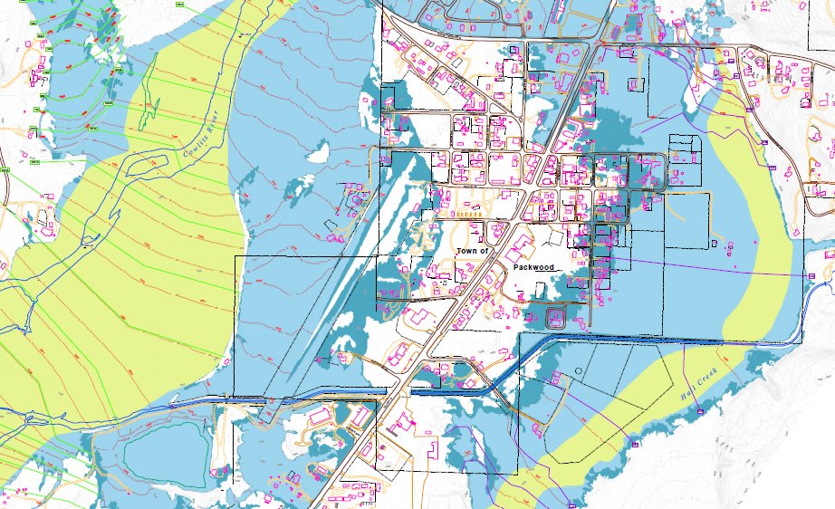
Lewis County Floodplain Manager Doyle Sanford said during last week’s meeting that the study also included many unstudied areas outside of Packwood. According to the study, roughly 16.7 miles of the Cowlitz River and 8.7 miles of nearby tributary creeks were studied.
“The existing FEMA (flood insurance rate maps) for the Cowlitz River were based on a 1979 study which concluded that a natural ridge along the left bank of the river upstream of Skate Creek Road would be overtopped, resulting in the inundation of the Packwood downtown area. The effective FEMA maps show the entire Packwood downtown area inundated to a depth of 3 feet during a 100-year flood event,” read background information provided in the study.
But that scenario failed to come to fruition when the river peaked into 100-year flooding in 2006. After that incident, the county was prompted to take a deeper look into what the real risk of flooding was to the East Lewis County town.
Broadly speaking, the floodplain designation has hindered development — both commercial and residential — in the unincorporated town of Packwood. Structures are required to be elevated, along with HVAC systems. Septic systems are required to be more robust, and inflated insurance rates provide a challenge for cash-strapped residents and businesses.
Grose said he remembers one resident telling him that she was paying about $200 more for flood insurance than she was for her mortgage.
The new maps, if approved by FEMA, could bring significant relief to flood insurance ratepayers and may clear some hurdles with the longtime effort to install a sewer system.
Grose said the effort to reexamine these maps started back when he was first serving as county commissioner. Funding to bring the contractor in was secured about two or three years ago.
He encourages ratepayers to renegotiate their rates once this process is complete.


