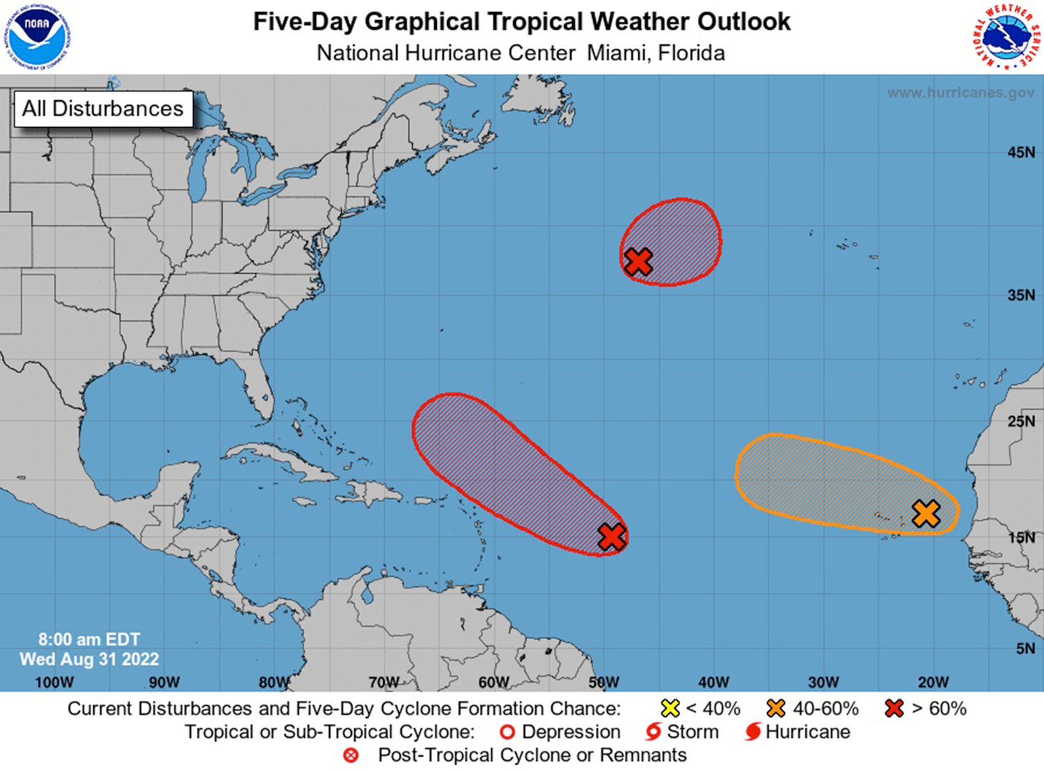
FORT LAUDERDALE, Fla. — Two weather systems in the Atlantic are likely to form into tropical depressions this week and a third could join them, according to forecasters with the National Hurricane Center.
One system in the central Atlantic is moving west-northwest. It is gradually developing but is expected to remain outside of the Caribbean Sea as it moves generally toward the U.S. east coast. The presence of wind shear near the Caribbean could be a hinderance to further development beyond a tropical depression, according to AccuWeather, the private forecasting service.
Another system further north is expected to strengthen this week as it moves drifts east away from land. Any development is expected to be short lived.
A third system moved off the coast of Africa and has a moderate chance of strengthening into a tropical depression as it gets further into the central Atlantic.
August has been unusually quiet in the tropics — if none of the systems strengthen on Thursday, it will be just the third time since 1961 that there has not been a named tropical Atlantic system in the month of August. But the three systems being tracked this week show that September is likely to heat up.
“It looks like September could really kick off an active period in the tropics. A steady wave train of energy rolling off Africa into the tropical Atlantic is expected to keep things active for a while across the Atlantic basin,” said AccuWeather meteorologist Brandon Buckingham.
The most active part of hurricane season is from mid-August to the end of October, with Sept. 10 the statistical peak of the season.
There have only been three named storms so far this season — Alex, Bonnie and Colin — with the last one, Colin, dissipating on July 3, meaning this 58-day streak is the third-longest time in Atlantic hurricane season history without a named storm since 1995.
The longest dry spell since 1995 has been 61 days, from June 18 through Aug. 18 in 1999. However, that two-month run of inactivity was followed by a frenetic conclusion of the hurricane season that featured five Category 4 storms (Bret, Cindy, Floyd, Gert and Lenny) and the drenching Category 2 Irene, which achieved a rarity, with its eye passing over Miami-Dade, Broward and Palm Beach counties in mid-October. There also was a 59-day streak during the 2007 season.
Forecasters say dry air, Saharan dust and wind shear have been among the reasons there haven’t been more storms this year.
Of the three named storms so far this season, only Alex made its presence known in South Florida by dumping as much as 12 inches of rain in some areas.
The next named storms will be Danielle and Earl.
Hurricane season ends Nov. 30.


