Lord of the Rings author J.R.R. Tolkien and Lewis County Senior Long Range Planner Mindy Brooks have at least one thing in common: Both compiled lengthy written work, illustrated by maps, where they detail a place and its characters.
That might be where the similarities end, though.
Brooks and other community development staff have created a draft of an existing conditions report for the Packwood area, which she presented on Tuesday night to the Lewis County Planning Commission. This represented another step in the yearlong creation of a subarea plan for the East Lewis County town, a community-informed roadmap to guide policy in Packwood for two decades following its implementation.
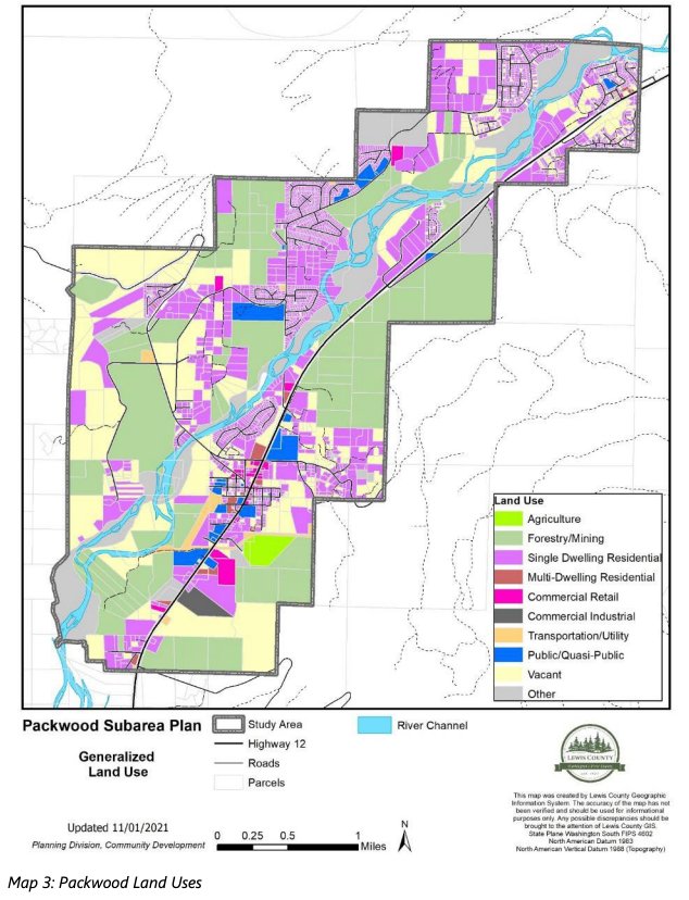
Informed by land managers, the White Pass School District, White Pass Ski Area staff, historians, county employees and many others, the draft is 68 pages long. Its nine chapters cover introductory context, Packwood-area history, land use, demographics, housing, transportation, public facilities and services, natural resources, and recreation and tourism. It includes 18 maps along with several figures and tables.
An “existing conditions report” may sound boring, but between the charts and parcel maps, it tells a story. It begins with Native Americans living along the Cowlitz River, explores the European settlement of the Big Bottom precinct, tells of the rise and fall of the lumber industry and enters into Packwood today: a recreation destination, bringing in droves of tourists as residents seek to maintain the tight-knit sense of community despite unaffordable housing.
Brooks presented the report in Tuesday’s meeting to allow planning commissioners to engage in an informational workshop. As the subarea plan continues to be guided by a community advisory committee, these presentations offer commissioners the chance to make comments and request additional information. The meetings are also capped off by the opportunity for public comment. After the subarea plan draft is finished, the planning commission completes a final workshop before recommending adaptation to the Board of County Commissioners.
“There's been an increase in development and tourism, and there’s coming changes to the map floodplain and a new sewer is in the near future, which means Packwood is changing. And the community wants and needs a voice in that change,” Brooks said.
To read the report online, visit https://lewiscountywa.gov/departments/community-development/rezones/comprehensive-plan-and-development-regulation-amendments/packwood-subarea-plan/.
Submit comments on the draft by March 31 to mindy.brooks@lewiscountywa.gov or by mail to Community Development, Planning Division at 2025 NE Kresky Ave., Chehalis, W, 98532, Attention: Mindy Brooks.
The following is a brief overview of the existing conditions report draft:
Land Use
• Packwood is unincorporated Lewis County land, designated as “rural” under the growth management act.
• The Packwood subarea study zone is divided into 5-, 10- and 20-acre plats as well as nine limited areas of more intense rural development (LAMIRDs), which are fixed outlines allowing for more development where it is historically “indicative of the town.”
• According to data from the Lewis County Assessor's Office, there are 448 “vacant” or undeveloped parcels in the study area.
Demographics
• Calculating the actual population of Packwood is challenging because of the high number of part-time residents, mostly those with vacation homes.
• The estimated population for the study area in 2021 is 558 full-time residents.
• There are 228 registered voters in the Packwood precinct.
Housing
• 70% of housing stock is single-family residential (SFR). 1,868 parcels are zoned as SFR, which are divided as the following: (these numbers are not additive and may have gaps and overlaps):
- 145 parcels are owner occupied
- 216 parcels are short-term rental (the total number of short-term rentals in Lewis County is currently being calculated by the assessor and will be available this spring)
- 613 parcels are personal vacation homes
- 444 undivided, vacant parcels
• SFR average sale prices grew from $150,000 in 2012 to $350,000 in 2021.
• Between 2012 and 2021, there was a 69% decrease in supply homes for sale.
• As of March 1, there were six three-bedroom rentals available in Lewis County and none in Packwood.
• The median household income in Packwood is $58,911.
• About 24% of the population have a “very low or extremely low income level.”
Transportation
• Lewis County maintains 29 miles of roadway in the study area, and the Washington State Department of Transportation manages U.S. Highway 12.
• Of the county roads, 27 miles are rural local collector roads and the remaining 2 miles are rural major collector. Roughly 25 of those miles are bituminous surface treatment (BST), 4 miles are hot mix asphalt (HMA) and less than 1 mile is gravel surface.
• The Packwood airport, owned by Lewis County, is 36 acres of land located at 132 Main St. W.
Public Facilities and Services
• Packwood is served by private onsite septic systems. The Department of Commerce has appropriated funds for study and construction of a sewer system. Lewis County Public Works is currently completing that contract.
• Packwood has two community wells that draw from an aquifer serving approximately 231 residents.
• The Packwood Fire Department (Fire District 10) has three stations servicing 320 square miles.
• The White Pass School District provides public education to the Packwood community. Enrollment in the district has been decreasing in recent years. In 2017, there were 405 full-time students. That had decreased to 320 full-time students in 2021. About 70% of the student population is on free or reduced-cost meals programs.
Natural Resources
• There are no agricultural or forestry resource lands in the study area; however, agricultural and forestry uses are allowed in all zones, except those designated as a park.
• Environmental resources are the Cowlitz River, streams, wetlands, flood area, hydric soils, steep slopes and wildlife habitat areas.
Recreation and Tourism
• Packwood is surrounded by the Gifford Pinchot National Forest and is located between Goat Rocks Wilderness Area, Tatoosh Wilderness Area, Mount Rainier National Park and White Pass Ski Area. These areas provide year-round recreational opportunities and generate a significant amount of tourism in Packwood.
• Within Packwood, there are three parks: Skate Creek State Park, a Cowlitz River access area under construction by Lewis County and the Packwood ball fields.
• Tourism in the Packwood area has increased significantly during the past three years. The Packwood Visitor Center reported 1,903 visitors in 2019, 3,979 visitors in 2020 and 6,351 visitors in 2021.
• Approximately 90% of the visitors in 2021 were from locations more than 50 miles from Packwood.
• Lodging in Packwood generates approximately $3.8 million in annual revenue.


