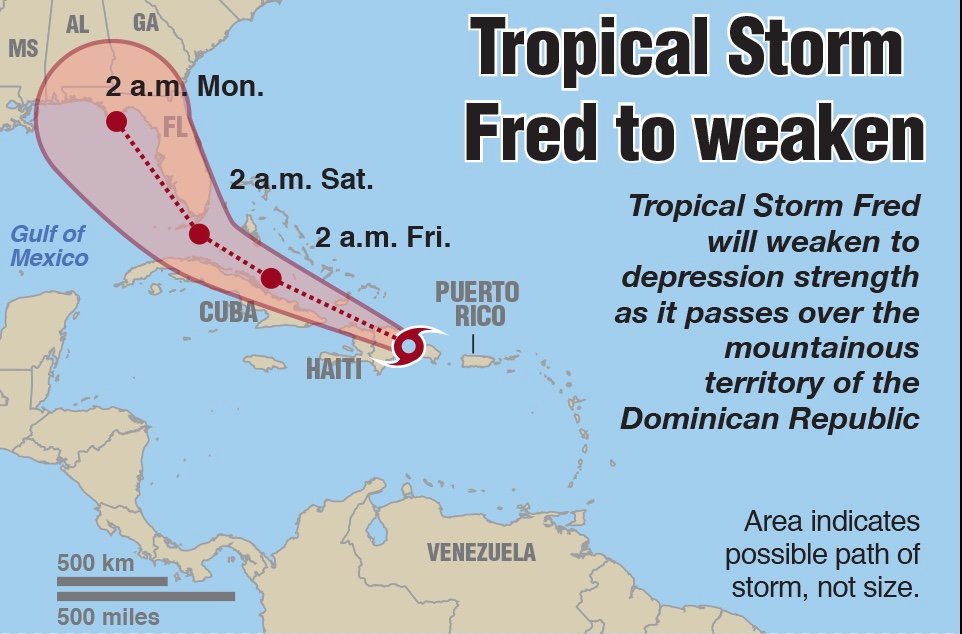
FORT LAUDERDALE, Fla. – Tropical Storm Fred will weaken to depression strength Wednesday as it passes over the mountainous territory of the Dominican Republic, the National Hurricane Center said in its 8 a.m. update.
But it’s expected to regain force over the ocean and remains on a course that could bring it to Florida by the end of the week.
The storm’s maximum sustained winds may reach up to 65 mph by Sunday, keeping it under the 74-mph minimum threshold for a hurricane.
The map of possible paths for the storm’s center moved South Florida from the center to the right edge of the cone of concern. The cone now shows a greater chance the storm will head into the Gulf of Mexico.
South Florida’s chances of experiencing tropical-force winds, which means 39 mph or more, stand at 10%, the National Weather Service said Wednesday morning. South Florida could experience heavy rain, with totals of four to six inches.
If the storm reaches South Florida, winds are most likely to arrive late Friday night or early Saturday, but they could reach the area sooner. There’s unusually high uncertainty about both the forecast track and likely strength of the storm, the service said.
As of 8 a.m. Wednesday, Fred had a top wind speed of 40 mph, just above the threshold for a tropical storm, the National Hurricane Center said, with tropical-storm-force winds extending out up to 45 miles from its center. The storm was moving west-northwest at 16 mph about 50 miles east-southeast of Santo Domingo in the Dominican Republic.
Fred is the sixth named storm of the season and the first since Hurricane Elsa moved through the Gulf of Mexico in early July. Fred also marks the first storm of the hurricane season’s busiest period, which runs from mid-August, reaches a peak around Sept. 10 and winds down in October.
Forecasters expect this to be an above-average hurricane season, with NOAA predicting up to 10 hurricanes by the time the season ends Nov. 30.
Fred is forecast to continue moving generally west-northwest from now until Friday before it takes a turn toward the north or northwest.
“How soon that northward turn begins will determine if the system strikes Florida or areas farther west along the Gulf of Mexico coastline,” according to AccuWeather.
Although Fred is forecast to strengthen once it clears the islands of the Caribbean, an upper-level low near Florida in the next couple of days could bring increasing west-southwesterly wind shear, which would limit Fred’s intensification, according to the National Hurricane Center.
Forecasters said projections of the storm’s path are unusually uncertain because it lacked a well-defined center, making its course harder to predict as it heads across the islands of the northern Caribbean Sea.
Fred is expected to move near or over Haiti and the Dominican Republic on Wednesday, move near the Turks and Caicos Islands and the southeastern Bahamas on Thursday, and move north of the northern coast of central Cuba on Friday, the National Hurricane Center said.
Meanwhile, the chances of another storm farther out in the Atlantic have increased. A cluster of thunderstorms off the African coast now has a 40% chance of organizing itself into a tropical cyclone, the catch-all term for closed-circulation storms that range in strength from depression to hurricane. The hurricane center on Tuesday had given it a 30% chance.
South Florida could be affected by heavy rain and flooding due to Fred late this week and into the weekend, according to the National Weather Service.
Tropical storm warnings and watches were in effect Wednesday for the Dominican Republic, Haiti, southeast Barbados, Turks and Caicos and surroundings areas.
Forecasters say swells could cause life-threatening surf and rip current conditions across the U.S. Virgin Islands and Puerto Rico through morning and then Haiti and the Dominican Republic later in the day.
Tropical Storm Fred is the first tropical cyclone to form in the Atlantic in more than a month, since the July 1 appearance of the storm system that would become Hurricane Elsa.
The number of storms is likely to increase in frequency over the next few weeks as the season ramps up toward its September peak. The next storm name after Fred is Grace.


